Search for answers or browse our knowledge base.
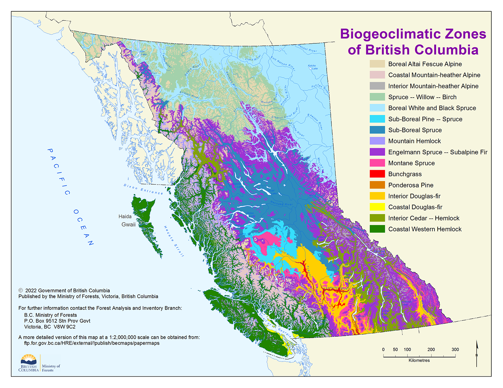
List of Biogeoclimatic Zones in BC
ALPINE ZONES :
The Alpine tundra zone is one of the larger biogeoclimatic zones located within British Columbia and is found especially along the Coast Mountains and southwest portion of the province. It is a rugged, relatively barren and tree-less environment, sparsely if at all populated because of its harsh climate.
Boreal Altai Fescue Alpine
Occurs in the northern Rocky, Skeena, Omineca and Cassiar mountains in the north and on the lee side of the Coast Mountains north of the Chilcotin. In the alpine as a whole, the primary vegetation consists of low-growing, evergreen shrubs. In this zone, the dominant species are dwarf willows, grasses (e.g., altai fescue [Festuca altaica]), sedges (Carex spp.) and lichens.
Coastal Mountain-heather Alpine
Occurs along the windward spine of the Coast Mountains and the mountains of Vancouver Island and Haida Gwaii/Queen Charlotte Islands. Features extensive beds of white mountain-heather (Cassiope mertensiana var. mertensiana) and pink mountain-heather (Phyllodoce empetriformis).
Interior Mountain-heather Alpine
Occurs in the southern third of the province in the Columbia Mountains, southern Rocky Mountains and on the lee side of the Coast and Cascade mountains. Dominant vegetation ranges from mountain-heathers in snowier areas to mountain-avens (Dryas spp.) on the driest sites.
Spruce – Willow – Birch
The spruce-willow-birch zone is one in which conditions are harsh. Winters are cold and snowy, while summers are short and cool. This pristine environment is however an ideal zone for recreation due to its outstanding scenery and abundant wildlife.
Boreal White and Black Spruce
The Boreal White and Black Spruce Zone forms part of the vast Boreal Forest that stretches across all of northern Canada. This zone has long areas of untampered wilderness, long cold winters and abundant wildlife, typical of the Canadian north. Forests and Muskeg dominate the area along with bears, grey wolves, caribou, and moose.
Sub-Boreal Pine – Spruce
The Sub-Boreal Pine-Spruce Zone is dominated by dry lodgepole pine
forests and abundant wetlands. There is little agricultural or urban development in the zone, but forestry and ranching are extensive. This zone contains fewer tree species than any other part of British Columbia. However, the dry forest undergrowth with its dwarf shrubs, herbs, lichens, mosses and trees are unique to the British Columbia.
Sub-Boreal Spruce
The Sub-Boreal Spruce zone is located in British Columbia’s interior. It is known for its cold winters and warm summers, deep snow cover and variety of wildlife. Popular activities include fishing, hunting and cross country skiing. The Sub-Boreal Spruce zone also has a vast network of lakes and rivers.
Mountain Hemlock
Located on the west coast. The Mountain Hemlock, Tsuga mertensiana, A close relative of the more dominant Western Hemlock. A medium-sized tree, it usually grows up to 50 meters tall and 1.5 meters in diameter at the base. The mountain hemlock prefers open conditions with sufficient light, and it can tolerate severe, cold weather better than many other species. The mountain hemlock is well adapted to deal with heavy snow fall and ice formations.
Englemann Spruce – Subalpine Fir
The Engelmann Spruce and sub-alpine Fir is a sub-alpine Fir Zone, which occupies the highest forested elevations in British Columbia. It is a larger biogeoclimatic zone in British Columbia, covered with old growth forest and crossed by fast flowing mountain rivers. This beautiful landscape contains much parkland and is important for recreation and timber harvesting.
Montane Spruce
The Montane Spruce Zone is located on a narrow, mid-elevation band in the southern interior of British Columbia. It is mostly forested but also contains many wetland areas. Its cool, dry climate draws many different species of wildlife and vegetation and makes the area an attractive site for recreation activities.
Bunchgrass
The Bunchgrass Zone is located in a narrow patch of land in south- central British Columbia. The warm and dry climate is attributed to the rain shadow cast over the zone by Coast and Cascade Mountains. Severe summer droughts make it difficult for trees to become established; therefore, grasses are the dominate vegetation specie. The diverse ecosystem in this zone supports a wide array of wildlife species and the fertile valley bottoms allow many agricultural crops to thrive particularly in the south.
Ponderosa Pine
The Ponderosa Pine Zone gets its name from the Ponderosa Pine forests that dominate the area. The ponderosa pine can be found in closed and opened forests and savanna. This is a hot, dry zone. It occupies low elevations in the dry valleys of the southern Interior Plateau and East Kootenays and consists of forests, grasslands and wetlands. The zone is home to a variety of birds, mammals, reptiles and amphibians, some of which are relatively rare and threatened by extinction.
Interior Douglas-Fir
The Interior Douglas-Fir Zone is located in the heart of British Columbia’s southern interior. There is a short, warm and dry summer with a shortage of moisture in the growing season. The ecology of the area reflects the shortage of moisture in much of this zone. The milder winters also attract many species of wildlife to this zone to spend their winter. Often described as “cattle country”, it is the land of rolling hills and valleys covered by dry grasslands and open forests. Although it is best known for cattle ranching and forestry, this zone also supports a rich diversity of wildlife species.
Coastal Douglas-Fir
The Coastal Douglas-fir, Pseudotsuga menziesii var. menziesii, is an evergreen tree with 2 species native to North America. It can grow up to 100 m tall and up to 5 meters in diameter. In the past, periodic wildfires created vast, almost pure stands of coastal Douglas-fir forests throughout the Pacific Northwest region of North America. Douglas-fir can come close in size to the giant redwoods, it once thrived on low-land areas near the ocean, but now most of the original old-growth Douglas-fir has been logged and the land converted to urban settings. Mostly found in lower mainland and Vancouver Island.
Interior Cedar – Hemlock
The Interior Cedar-Hemlock Zone is located predominately in southeast British Columbia. Easterly flowing air masses cause long, warm summers and cool wet winters that are favourable for an abundant species of trees. The climate of this zone makes the forestry industry very productive.
Coastal Western Hemlock
The Coastal Western Hemlock, Tsuga heterophylla, is the dominant species on the west coast of North America. A large tree, it usually grows up to 70 meters tall and 2.5 meters in diameter. With a narrow crown and conspicuously drooping new growth at the top of the tree. It is characterized by down-sweeping branches and delicate feathery foliage. The Western Hemlock can be found readily throughout the forests in Alberta, British Columbia, Alaska, Montana, Idaho, Washington, Oregon and California between the sea level and up to 2000 m elevation in coastal to sub-alpine forests.
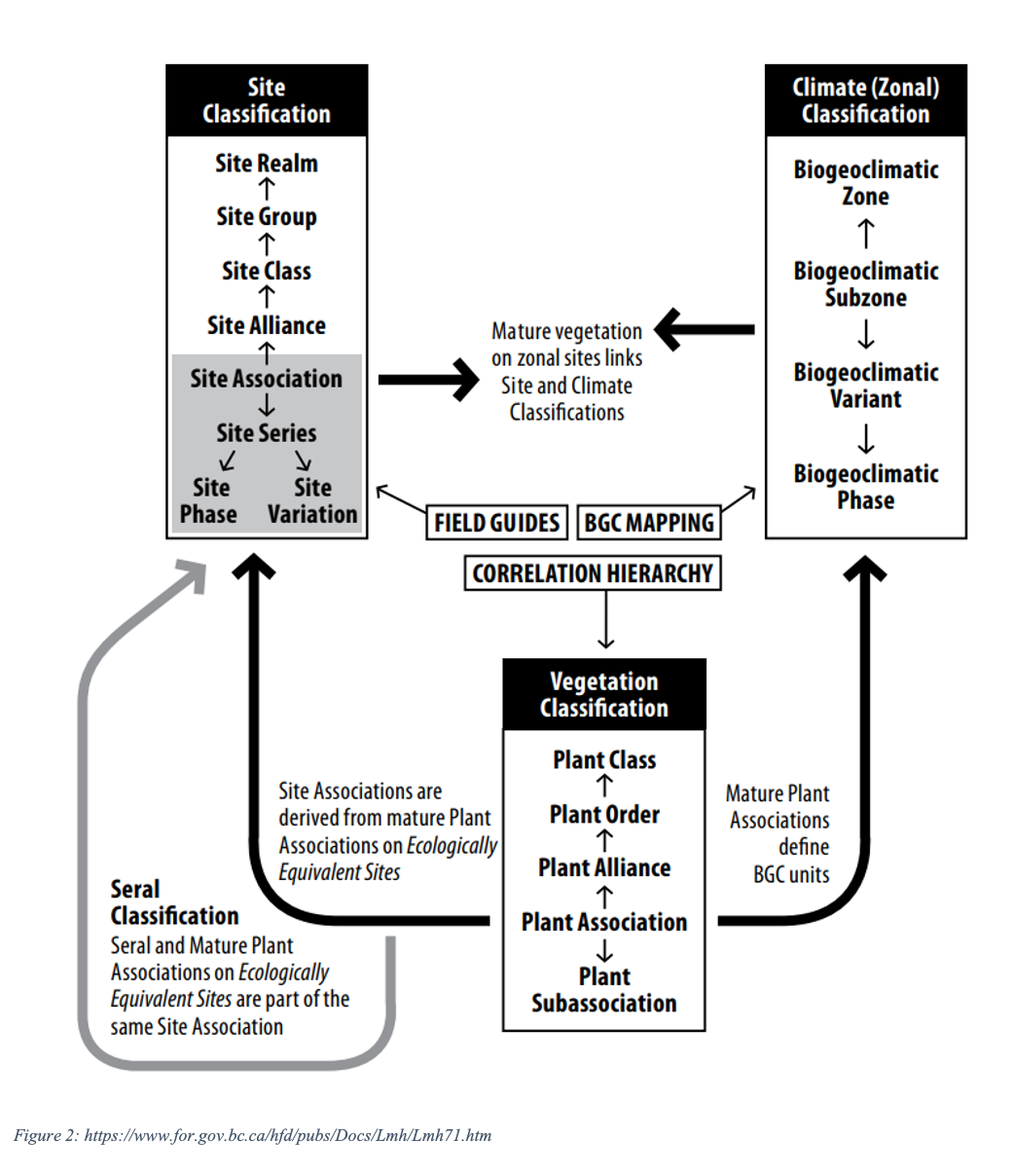
Site Classification
Each zone is named after dominant tree species of late successional stages and a descriptor of the general climate or region. Zones are large geographic areas with relatively uniform climate, i.e. similar regional or macroclimate.
Site associations provide a linkage between the vegetation (plant associations) and climate classifications at the subzone level. The spatial distribution of a subzone reflects the geographic area where the climate conditions are consistent enough to support the same mature plant community.
Climate
Climate is the overarching factor influencing the development of terrestrial ecosystems. Similar climates are classified and mapped as biogeoclimatic units in the climate classification component.
Vegetation
Vegetation of mature ecosystems is emphasized in biogeoclimatic ecosystem classification (BEC) as it is considered to be the best integrator of the combined influence of the environmental factors affecting a site. Vegetation is emphasized in the BEC system because it is readily visible and can be used to integrate the climate, abiotic environment, and ecological history of a site.
Vegetation communities change with time and disturbance, therefore the vegetation classification uses the “potential vegetation” of a group of sites, along with selected environmental properties, to delineate site units.
Vegetation units are determined by grouping plot data and then comparing the resulting units in a series of vegetation tables.
Subzones and Variants
Zones can be further divided into detailed climatically distinct subzones. Subzones are named first with a descriptor of relative precipitation (moisture) and then either relative temperature or continentality. Subzones that have considerable variation in climate are further divided into variants. Variants are areas which are slightly drier, wetter, snowier, warmer, or colder than typical but with a vegetation community that is not different enough to be considered a unique or distinct subzones. Numbers are used to identify variants.
Refinement and expansion of the classification system is ongoing and has been extended to seral ecosystems and non-forested ecosystems such as wetlands and riparian areas, grasslands, alpine tundra and parkland.
More information:
- BC Conservation Data Centre
- A Field Guide to Ecosystem Classification and Identification for Southeast British Columbia
- Biogeoclimatic Ecosystem Classification Program